


April 15, 2019
Spring Snows in U.S. not caused by Global Warming

See full image here.
Timothy Birdnow
They're doing it again!
Yes, with a spring snow moving across the nation the media is yet again calling it a sign of global warming.
Funny; I thought snow came when water vapor struck cold air. Silly me!
From CBS News:
Now, big spring snows are hardly unique, and in fact the claim has been debunked on any number of occasions, including by yours truly several years ago. See also this from 2-17.
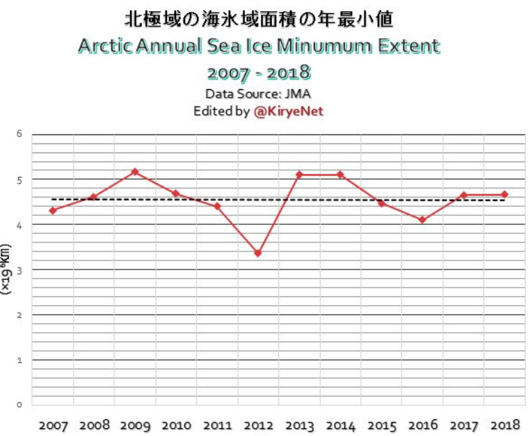
In fact, polar sea ice has remained stable over the last twelve years despite the "emergency" of global warming. And while this last winter saw the seventh worst year for Arctic ice (tied, in fact, for seventh) that is only over the last forty years, so it is hardly an emergency.
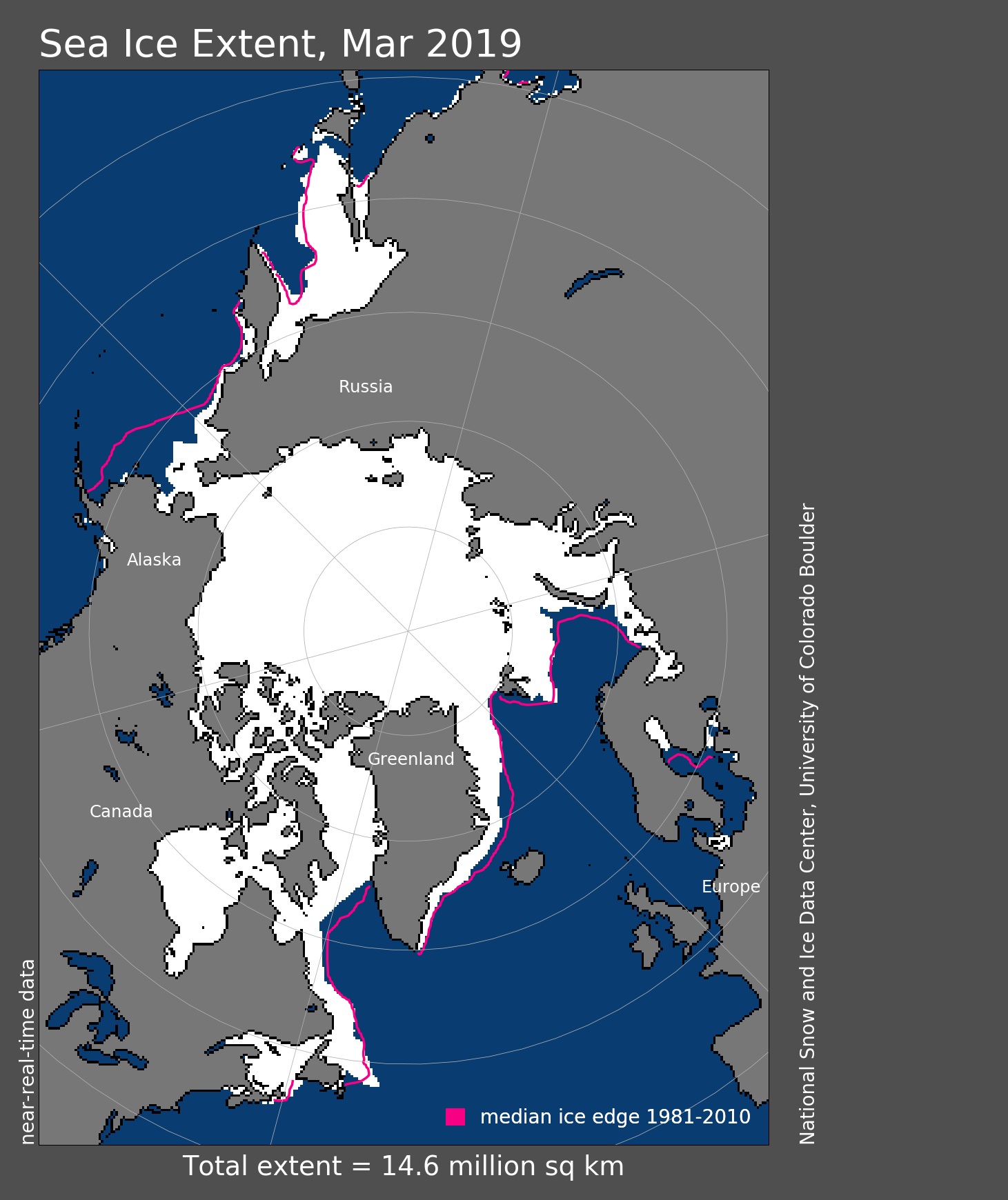
As you can see below, the problems lie in the Barents Sea, A shallow body of water, which is influenced by warming ultimately from the Gulf Coast Current, and in the Bering Sea, which itself is influenced by Pacific currents. This has nothing to do with atmospheric temperatures, but rather ocean movements, a natural cycle.

Low pressure zones over both the Bering and Barents Seas were the culprits in a warmer than average winter.
From the National Snow and Ice Data Center article:
Overall, Arctic weather in March featured low pressure and above average temperatures. Two low pressure centers at sea level, one over the Bering Sea and the other over the Barents Sea, dominated the atmospheric circulation pattern. Low pressure over the Barents Sea brought cloudy and cool conditions to the immediate region, but also funneled warm air into the central Arctic Ocean. Air temperatures at the 925 mb level (about 2500 feet above sea level) were above average over most of the Arctic region, with the exception in the Atlantic sector of the Arctic Ocean. Temperatures were far above average, locally exceeding 10 degrees Celsius (18 degrees Fahrenheit), over the Beaufort Sea, northeast Alaska, and northwest Canada.
The pattern of overall low pressure across the Arctic in March was manifested as a persistent positive phase of the Arctic Oscillation (AO), a pattern that started during the second week of February. A positive AO in winter has in the past favored low September ice extent. This is in part due to a wind pattern tending to advect older, thicker ice out of the Arctic through the Fram Strait. The wind pattern associated with the positive AO also tends to pull ice away from the Siberian coast, resulting in thinner ice in the region that readily melts out during summer. However, with the overall thinning of the Arctic ice cover, the relationship between winter AO phase and September sea ice extent is not as clear as it used to be.
End excerpt.
Get that? It was the phase change of the Arctic Oscillation that led to the lower ice going into the winter.
And here's more from the NSIDC:
Moderation marked the 2018 to 2019 winter. Air temperatures at the 925 mb level were average to slightly above average over most of the Arctic Ocean, with only the southern Beaufort Sea being especially warm with temperatures 5 degrees Celsius (9 degrees Fahrenheit) higher than average.
End excerpt.
Average air temps!
Let us continue:
For much of the Arctic, sea ice extent was near average through most of the winter. As noted in a previous post, the most compelling feature of the winter was the substantial ice loss during February and early March in the Bering Sea, leading to nearly ice-free conditions.
End excerpt.
So the lack of ice had little to do with unusual warmth.
Which brings us back to the spring snows over the U.S.; how is it that a dearth of ice in the Arctic, a warmer Arctic, caused a snowstorm in the lower forty eight? The reality is it has nothing to do with Global Warming and everything to do with the low pressure zones (aka the polar vortex)that have parked themselves over the northern oceans all winter. Low pressure in the Arctic means warm air from the south can move in and cold air move out. That is normal enough. The polar vortex usually breaks up in spring, but with the weak vortex splitting into two early, warmer southern air was able to move it, and the end result was cold air moving south to generate snow in the U.S.
Oh, and a new El Nino has started in the Pacific. According to Climate.gov.
Here is another point to ponder:
The Arctic ocean is warmest when the air in the Arctic gets colder. This is when the sea ice north of Svalbard decreases. Researchers found changes in the physical marine environment that was so great that the ecosystems north of Svalbard had changed.
A new study shows that the largest influx toward the Arctic Ocean takes place in autumn and early winter and that the water is also warmest at this time of year.
Powerful pulses of water warmer than five degrees enter the area at the time of the year when the sea ice should freeze. But even if the air temperature is far below freezing, even during the months without the sun to warm the ground, new sea ice fails to appear.
«Only if the wind helps by blowing ice and fresh surface water from the interior of the Arctic Ocean or from the east will we see an ice cover on the Atlantic influx. We have been watching the ice cover on the Arctic Ocean become significantly thinner in recent years, along with reductions in distribution in time and space. This also reduces the supply of fresh water from the north,» quotes Angelika Renner, an oceanographer at the Marine Research Institute and one of the researchers behind the study.
The mechanism that causes the warm and salty waters from the south to remain below the insulating cold and fresh layer of water in the north appears to have been weakened in recent years.
End excerpt.
This in no way suggests global warming, but rather changes in current patterns. In other words, this has everything to do with the North Atlantic Oscillation and Arctic Oscillation.
See full image here.
Timothy Birdnow
They're doing it again!
Yes, with a spring snow moving across the nation the media is yet again calling it a sign of global warming.
Funny; I thought snow came when water vapor struck cold air. Silly me!
From CBS News:
The blizzard pummeling the Upper Midwest and Plain States has already dished out widespread thundersnow, winds gusts close to 70 mph and over 2 feet of snow in spots. On top of that, it's happening in the month of April, just three weeks after the record-breaking bomb cyclone. By any measure these storms are considered extreme, but climate change is making them even more extreme.
The intensity of the storm is being powered by a sharp 60-degree temperature contrast — 80s in the Southeast and 20s in the Dakotas. Strong contrasts are typical for spring as warm and moist air surges north from the Gulf of Mexico and winter cold remains stubborn. But there's an added feature heightening the contrast called "Arctic amplification."
This anomaly map is off the charts. Temperatures range from 30 degrees below normal to 20 degrees above normal on either side of the system. pic.twitter.com/2i0c0x3cPC
— Meteorologists United on Climate Change (@MetsUnite) April 11, 2019
Over the past couple of decades, the Arctic has warmed much faster than of the mid-latitudes, especially in winter. Warming of the globe is being caused by heat trapping greenhouse gases produced by the burning of fossil fuels. In the Arctic this warming effect is enhanced by melting sea ice. Ice typically reflects sunlight, keeping the Arctic cool. But since 1970 Arctic sea ice volume has decreased by 50%. Right now, Arctic sea ice extent is at record low levels.
Now, big spring snows are hardly unique, and in fact the claim has been debunked on any number of occasions, including by yours truly several years ago. See also this from 2-17.
In fact, polar sea ice has remained stable over the last twelve years despite the "emergency" of global warming. And while this last winter saw the seventh worst year for Arctic ice (tied, in fact, for seventh) that is only over the last forty years, so it is hardly an emergency.
As you can see below, the problems lie in the Barents Sea, A shallow body of water, which is influenced by warming ultimately from the Gulf Coast Current, and in the Bering Sea, which itself is influenced by Pacific currents. This has nothing to do with atmospheric temperatures, but rather ocean movements, a natural cycle.
Low pressure zones over both the Bering and Barents Seas were the culprits in a warmer than average winter.
From the National Snow and Ice Data Center article:
Overall, Arctic weather in March featured low pressure and above average temperatures. Two low pressure centers at sea level, one over the Bering Sea and the other over the Barents Sea, dominated the atmospheric circulation pattern. Low pressure over the Barents Sea brought cloudy and cool conditions to the immediate region, but also funneled warm air into the central Arctic Ocean. Air temperatures at the 925 mb level (about 2500 feet above sea level) were above average over most of the Arctic region, with the exception in the Atlantic sector of the Arctic Ocean. Temperatures were far above average, locally exceeding 10 degrees Celsius (18 degrees Fahrenheit), over the Beaufort Sea, northeast Alaska, and northwest Canada.
The pattern of overall low pressure across the Arctic in March was manifested as a persistent positive phase of the Arctic Oscillation (AO), a pattern that started during the second week of February. A positive AO in winter has in the past favored low September ice extent. This is in part due to a wind pattern tending to advect older, thicker ice out of the Arctic through the Fram Strait. The wind pattern associated with the positive AO also tends to pull ice away from the Siberian coast, resulting in thinner ice in the region that readily melts out during summer. However, with the overall thinning of the Arctic ice cover, the relationship between winter AO phase and September sea ice extent is not as clear as it used to be.
End excerpt.
Get that? It was the phase change of the Arctic Oscillation that led to the lower ice going into the winter.
And here's more from the NSIDC:
Moderation marked the 2018 to 2019 winter. Air temperatures at the 925 mb level were average to slightly above average over most of the Arctic Ocean, with only the southern Beaufort Sea being especially warm with temperatures 5 degrees Celsius (9 degrees Fahrenheit) higher than average.
End excerpt.
Average air temps!
Let us continue:
For much of the Arctic, sea ice extent was near average through most of the winter. As noted in a previous post, the most compelling feature of the winter was the substantial ice loss during February and early March in the Bering Sea, leading to nearly ice-free conditions.
End excerpt.
So the lack of ice had little to do with unusual warmth.
Which brings us back to the spring snows over the U.S.; how is it that a dearth of ice in the Arctic, a warmer Arctic, caused a snowstorm in the lower forty eight? The reality is it has nothing to do with Global Warming and everything to do with the low pressure zones (aka the polar vortex)that have parked themselves over the northern oceans all winter. Low pressure in the Arctic means warm air from the south can move in and cold air move out. That is normal enough. The polar vortex usually breaks up in spring, but with the weak vortex splitting into two early, warmer southern air was able to move it, and the end result was cold air moving south to generate snow in the U.S.
Oh, and a new El Nino has started in the Pacific. According to Climate.gov.
Here is another point to ponder:
The Arctic ocean is warmest when the air in the Arctic gets colder. This is when the sea ice north of Svalbard decreases. Researchers found changes in the physical marine environment that was so great that the ecosystems north of Svalbard had changed.
A new study shows that the largest influx toward the Arctic Ocean takes place in autumn and early winter and that the water is also warmest at this time of year.
Powerful pulses of water warmer than five degrees enter the area at the time of the year when the sea ice should freeze. But even if the air temperature is far below freezing, even during the months without the sun to warm the ground, new sea ice fails to appear.
«Only if the wind helps by blowing ice and fresh surface water from the interior of the Arctic Ocean or from the east will we see an ice cover on the Atlantic influx. We have been watching the ice cover on the Arctic Ocean become significantly thinner in recent years, along with reductions in distribution in time and space. This also reduces the supply of fresh water from the north,» quotes Angelika Renner, an oceanographer at the Marine Research Institute and one of the researchers behind the study.
The mechanism that causes the warm and salty waters from the south to remain below the insulating cold and fresh layer of water in the north appears to have been weakened in recent years.
End excerpt.
This in no way suggests global warming, but rather changes in current patterns. In other words, this has everything to do with the North Atlantic Oscillation and Arctic Oscillation.
Posted by: Timothy Birdnow at
10:38 AM
| No Comments
| Add Comment
Post contains 1279 words, total size 12 kb.
32kb generated in CPU 0.1303, elapsed 0.2982 seconds.
35 queries taking 0.2897 seconds, 184 records returned.
Powered by Minx 1.1.6c-pink.
35 queries taking 0.2897 seconds, 184 records returned.
Powered by Minx 1.1.6c-pink.

